Private Estate
Create a secluded Lowcountry residence with room for outdoor living, gardens, recreation, workshops and future improvements.
 3041 Nye View
 Circle · Mount Pleasant, SC
3041 Nye View
3041 Nye View Circle · Mount Pleasant, SC

Approximately 4.57 acres with open ground, live oaks, cultivated plantings, a sizable producing vineyard, well, septic, power and active AT&T Fiber.
3041 Nye View Circle
One distinctive tract combines usable land, wooded privacy, existing infrastructure and close connections to North Mount Pleasant, Charleston and the surrounding Lowcountry.
Property overview
Open ground and wooded areas are complemented by live oaks, established trees and shrubs, plus five approximately 75-foot rows of producing bronze muscadine vines, commonly called scuppernongs. Existing well, septic, electrical service and active AT&T Fiber provide a practical starting point for the next owner.
All facts, dimensions, zoning, utility information and potential uses are subject to independent verification.
Possible paths
Create a secluded Lowcountry residence with room for outdoor living, gardens, recreation, workshops and future improvements.
Explore a multigenerational arrangement with separate living spaces or accessory structures, subject to applicable approvals.
Evaluate subdivision, small-scale residential development or a long-term land strategy under current regulations and infrastructure requirements.
Build upon the producing bronze muscadine vineyard with gardens, an orchard or other small-scale agricultural uses. Private equestrian use may also be explored, subject to County requirements, site planning and approvals.
S-3 zoning and use potential
Charleston County’s S-3 use table identifies residential, agricultural, animal-related, institutional and community-oriented uses that may be available through different review paths. The examples below are selective rather than comprehensive.
View the Official County Use TableAllowed by right
These uses do not require a Special Exception, but zoning permits, dimensional standards and all other applicable regulations still apply.
Subject to conditions
A conditional use is possible only when every applicable use-specific condition and development standard is satisfied.
Special exception review
These uses are not preapproved. They require Board of Zoning Appeals review and may be approved, approved with conditions or denied.
Charleston County's current S-3 regulations provide enhanced density opportunities for qualifying Affordable and Workforce Dwelling Unit developments within the Urban/Suburban Area. Depending on the percentage of qualifying dwelling units, permitted density may increase from the standard S-3 maximum of 3 principal dwelling units per acre to 4, 5 or 7 dwelling units per acre.
Based on approximately 4.57 acres, these density rates correspond mathematically to the gross density equivalents shown above, before consideration of whole-unit rounding, access, infrastructure, dimensional standards, stormwater, environmental conditions and other governmental requirements.
Developers pursuing qualifying workforce, mixed-income or affordable housing concepts may also have access to local, regional and state financing and development-assistance programs.
Newly launched Lowcountry initiative targeting $100 million over five years, with grants, loans and co-investment intended to support creation and financing of housing.
Explore the $100M regional fund →Below-market financing for qualifying projects that create or preserve affordable and workforce housing in Charleston County.
Explore the trust fund →Charleston County program supporting qualifying acquisition of real property for long-term affordable and workforce rental and for-sale housing development.
Explore land-acquisition assistance →State and federal housing-development resources include the Small Rental Development Program for qualifying affordable rental projects containing 4–39 units, along with other financing and tax-credit programs.
Explore SC Housing programs →Programs are independently administered and subject to eligibility, funding availability, competitive application cycles, affordability requirements and other conditions. References are provided as potential resources for prospective developers and do not represent funding approval or eligibility of this property.
Potential developer opportunity: These provisions may create additional development strategies for workforce, mixed-income or affordable residential housing beyond conventional base-density S-3 development.
View Charleston County Affordable / Workforce Density Standards →
*Gross density equivalents are mathematical zoning calculations only and do not represent an approved unit count or guaranteed development yield.
Zoning classifications describe possible regulatory paths, not guaranteed property entitlements. Suitability depends on the exact proposal, use definitions, access, acreage, setbacks, buffers, parking, utilities, septic capacity, site-plan requirements and all governmental reviews in effect at the time of application. Prospective buyers should obtain independent confirmation from Charleston County and their own land-use professionals.
Gallery
Additional property photography coming soon.
Property film
A cinematic aerial and ground tour is being prepared. Contact us for current video or to arrange a private tour.
Location
Positioned within developed North Mount Pleasant, the property occupies a rare unincorporated County pocket surrounded by major established communities. Grocery shopping is approximately six minutes away, with marinas, waterfront dining, sports facilities, parks and other daily conveniences also close by.
Historic roots: The property lies within land historically associated with Laurel Hill Plantation, one of the early plantation tracts that shaped this part of Mount Pleasant. Its recorded plat reference continues to carry the Laurel Hill name, adding a distinctive layer of Lowcountry history to the property.
Private approach: A private gated driveway extends approximately one-eighth mile into the property, while the parcel itself continues well beyond the driveway’s end.
The current owner regularly uses the surrounding public trail, bicycle and sidewalk network. Membership rights and access to privately owned community facilities, amenities or routes are not represented and should be independently verified.
Area facts & Lowcountry lifestyle
Town-wide market indicators provide useful context, while the nearby mix of shopping, dining, recreation, boating and parks demonstrates the property’s day-to-day convenience.
Mount Pleasant market snapshot
Town-wide Census figures help illustrate the strength of the surrounding residential market. They are presented as community context and are not property-specific projections.
Source: U.S. Census Bureau QuickFacts, Mount Pleasant town. Income, housing, ownership and education figures cover 2020–2024.
Close to what matters
Harris Teeter at Rivertowne Place and Lowe’s Foods on Highway 41 provide two especially convenient grocery options.
Waterfront dining, marina access and designated transient docks on the Wando River, with indoor and outdoor seating and seasonal Lowcountry fare.
Visit Wando River GrillA waterfront baseball complex with five AstroTurf fields, tournaments and family-oriented sports events on Highway 41.
Visit Shipyard ParkNearby fields, courts, playgrounds, trails, a pool and organized recreation.
Explore the complexA 745-acre nature park with miles of unpaved trails through woods and meadows, an oak allée, lake overlook, birding and mountain-biking opportunities.
Explore Laurel HillAn 18-hole course, practice facilities and clubhouse amenities are close by.
Visit Dunes West GolfOne of America’s oldest working farms, with historic grounds, the Avenue of Oaks, gardens, agricultural traditions, and interpretation of Gullah and African American history.
Explore Boone HallA broad mix of shopping, dining, cinema, events, hotel accommodations and personal services.
Explore Towne CentreA 943-acre nature-oriented park with trails, boardwalks, water access, picnic areas and recreation.
Explore the parkPublic beach access and the Atlantic Ocean are within an easy Lowcountry outing.
View beach park informationWaterfront dining, boardwalks, paddling, boating and one of Mount Pleasant’s signature gathering places.
Downtown culture, dining, employment, arts, hospitality and regional attractions remain accessible.
Approximate roadway distances and estimated drive-time ranges were checked using Google Maps on July 24, 2026, from 3041 Nye View Circle. Routes, private-road conditions, traffic, construction and time of day can materially affect travel.
Public parcel information
The summary below is copied from Charleston County's public GIS and real-property systems for convenient preliminary review. Official records and the recorded survey control.
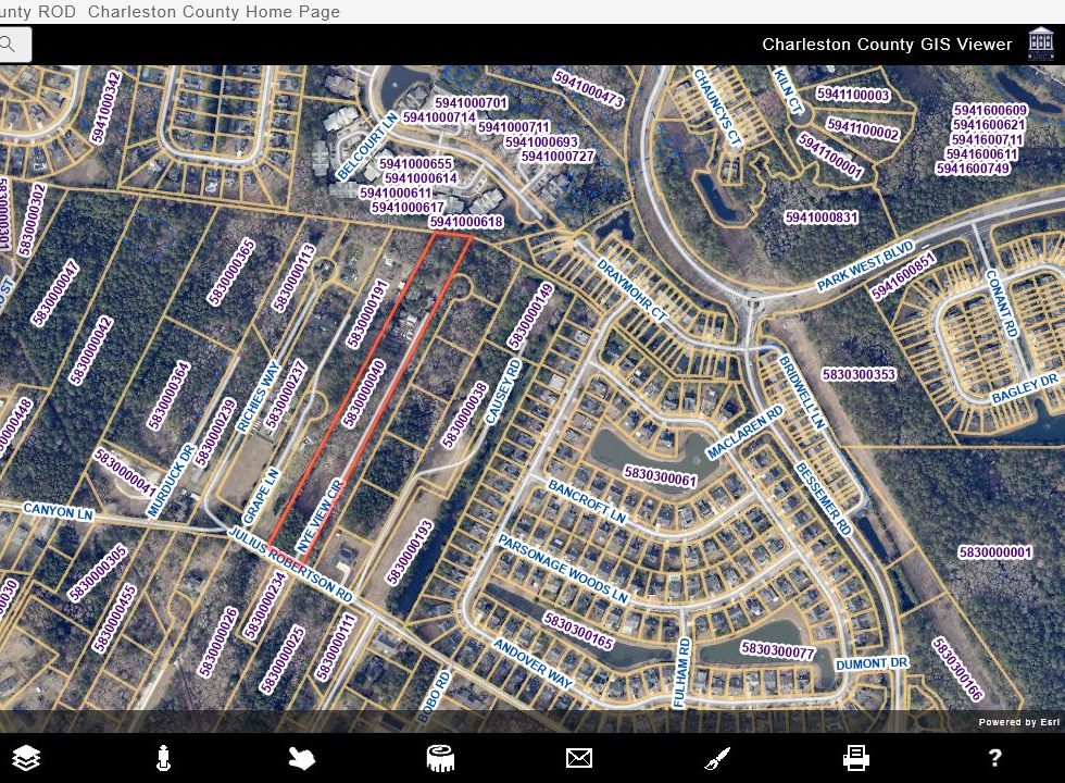
The property sits in an unincorporated County pocket surrounded by established Town communities, combining its present County framework with the option to explore voluntary annexation.
The owner reports that the parcel touches Town limits. Eligibility, resulting zoning, costs and services should be confirmed while comparing the two options. Review the Town’s official annexation information.
Search PID 5830000040 in the County viewer. Data is informational, can change, and should be independently verified with Charleston County, the Register of Deeds and a licensed surveyor.
Buyer agents & brokers
3041 Nye View is being marketed directly by the owner, but licensed buyer agents and brokers are expressly welcome to bring qualified purchasers and participate in the transaction.
Seller is willing to consider buyer-broker compensation in connection with an acceptable transaction. Compensation is not set by law, is fully negotiable, and must be established in a separate written agreement before any obligation to pay arises.
Buyer agents may request the full property package, coordinate private showings, submit due-diligence questions and present offers directly to the owner. Proof of funds or lender qualification may be requested before extended property access.
Public materials include parcel/GIS information, zoning context, property brochure, fact sheet, recorded plat/survey references and a developer due-diligence package. All development concepts remain subject to independent verification.
South Carolina buyer-broker compensation can be documented with the appropriate current transaction forms or other mutually acceptable written agreement. Buyer representatives should identify their requested compensation with or before an offer so terms can be evaluated together.
The seller is not offering real-estate brokerage services and does not represent the buyer. Buyer agents remain responsible for their own agency disclosures, buyer representation agreements, licensing requirements and compliance obligations. Nothing on this page creates a compensation obligation or brokerage relationship.
Due diligence
Important notice
Any references to density, subdivision, estate use, accessory structures, commercial activity or development potential are conceptual only and do not constitute a representation of approval. Buyers should independently verify all material facts with Charleston County and other applicable authorities.
Private inquiries
Direct property inquiries are welcome by phone or email.
The owner will consider proposals for the property as a whole and, subject to governmental approvals, survey requirements and lender consent, may consider proposals involving a future subdivided parcel. No separate subdivided lot is presently offered for sale.